|
|
 subscribe
|
subscribe
|
more mosque info |
. . . . . . . . . . . . . . . . . . . . . . . . . . . . . . . . . . . . . . . . . . |
Gulf War II - CBS Baghdad webcam: where
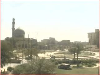
But where is this mosque? With the daily bombardment of Baghdad why don't we see more pyrotechnics?
As interesting as it's been having a realtime view into Baghdad it's been frustrating not knowing more about our perch.
Well, here's some minor detective work, some satellite maps, and a pretty good guess at the answer. Although I still don't have the name of the mosque (which would certainly lead to interesting information about it).
My first clue came just after the Palestine Hotel was hit by tank round. The resulting frenetic news report via webcam showed me that the mosque is right next to the hotel. Eureka; we have it! Searching the net a bit I found this description by one Wade Hudson:
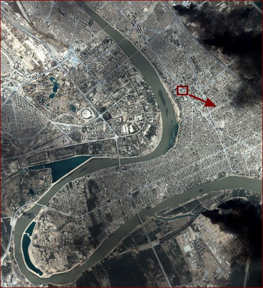
Searching around the news web sites for a map which includes the Palestine Hotel, I was able to get a feeling for the major intersections near which it lies. Then, heading back to a high-resolution satellite image of Baghdad which I found recently I located the oval roundabout we see inbetween our vantage point and the mosque. (The photo below shows a greatly reduced version of the satellite image. The square shows the area to be enlarged. The arrow shows our angle of view, which you will note is exactly away from the sites of the fiercest bombings on western side of the Tigris River.)
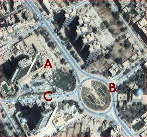
 Here's a full-size view of the roundabout. I believe that 'A' marks the site of the camera, which points in the direction of 'B', the mosque. 'C' is the tower which was hit, so that would be the Palestine Hotel. So I'm guessing that 'A' is the Andalus Apartments.
 I've done some more searching, and have found that an Omar Al Faroukh mosque is on Palestine Street. Perhaps this is our mosque.
|
| Have you found errors nontrivial or marginal, factual, analytical and illogical, arithmetical, temporal, or even typographical? Please let me know; drop me email. Thanks! |
 Here's the